

Drone Mapping Services in South Puget Sound
High-resolution orthomosaic maps, 3D site models, and interactive aerial images for construction, real estate, and land development — delivered by a local, FAA-certified pilot.
Focus 56 provides aerial drone mapping services for the people who care for land — and the families, members, and guests who use it. If you run a tree farm, a resort, a golf course, an HOA, or a ranch, you know your property from the ground. Drone mapping services show it from above, as it is today: every building, every path, every stand of trees, every interesting feature in one seamless map you can open, explore, and share.
Certified. Insured. Local.
Focus 56 is operated by Dan Olsen, an FAA Part 107 certified remote pilot with full liability insurance and 30 years of field experience in arboriculture and utility vegetation management. Based in Lacey, WA, Focus 56 serves clients across Thurston, Pierce, Lewis, and Mason counties — no travel fees within the four-county service area.
- FAA Part 107 certified — fully legal for commercial operations
- Fully insured — liability coverage on every flight
- Proficient in Geographic Information Systems and making maps — your data is processed and delivered by a mapmaker, not just a pilot
- 30 years as an Arborist — As a current ISA Board Certified Master Arborist, he reads canopy and tree health from the air at a level no other pilot in the region can match
- Local to South Puget Sound — fast turnaround, no travel fees in the service area
The Best Aerial Photo of Your Property Is Years Old
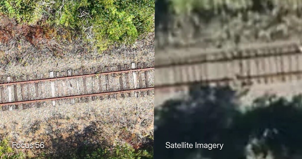
That’s the quiet problem most property owners live with. The satellite view of your land was taken two to five years ago — before the new blocks went in, before the storm, before the expansion. It’s low-resolution, so you can’t see buildings, paths, tree condition, or drainage. And you can’t do anything with it — you can’t measure on it, you can’t share a clean version with your board, and you wouldn’t put it on your website.
A ground survey would fix the “old” problem and create two new ones: weeks of scheduling, and a bill in the thousands for precision you’ll never use.
Focus 56 orthomosaic maps are current, sharp, and shareable.
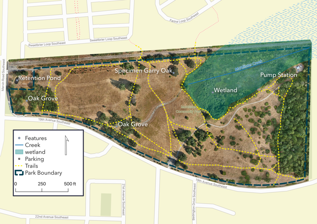
Explore a live demo — McAllister Park interactive map · Horizon Pointe interactive map
Focus 56 Drone Mapping Services Include
Current imagery, flown this week. Your map shows your property as it is now — this season’s growth, this month’s changes, post-storm conditions. Satellite imagery is a snapshot of the past. A drone map is a current snapshot, can be updated frequently and is ideal for monitoring and managing dynamic environments.
5 to 50 times more detail than satellite imagery — accurate down to the fence post. A single orthomosaic is a geometrically corrected aerial image of your whole property, sharp enough to see individual trees, tee boxes, fence lines, roof conditions, and drainage patterns. At 1–3 cm per pixel, you can count the fence posts.
Faster than traditional surveying. A typical mapping flight takes 30–60 minutes on-site. Post-processing and delivery within 24–48 hours. Compare that to scheduling a ground survey crew and waiting weeks for results.
Honest, planning-grade accuracy. Focus 56 maps are georeferenced to meter-level accuracy — right for planning, documentation, monitoring, and presentation. If your project needs survey-grade precision — legal boundaries, engineering design, volumetrics — we’ll point you to a licensed land surveyor — because we don’t sell tools that don’t fit the job.
A fraction of the cost Drone mapping services typically run $500-1,500 depending on scope and acreage. Traditional surveying for the same coverage area can cost $2,000-5,000 or more. When you need current aerial data for planning — not a legal boundary survey — drone mapping is the practical choice.
An arborist’s eye on your site Dan’s 30 years in arboriculture means he sees what other pilots miss. Tree health, canopy coverage, root zones, hazard trees, vegetation density — details that matter for site planning, construction staging, and land development or maintenance planning.
How Drone Mapping Works — 4 Simple Steps
Step 1: Site Consultation Call or email with your project details. We review the site on satellite imagery, confirms airspace authorization requirements, and provides a fixed quote based on acreage and deliverables. No surprise fees.
Step 2: Flight Planning & Authorization Focus 56 files any required LAANC (Low Altitude Authorization and Notification Capability) requests with the FAA, checks weather minimums, and plans flight patterns for optimal coverage and resolution. Every flight is logged and documented per Part 107 requirements.
Step 3: On-Site Flight The flight captures hundreds of overlapping high-resolution images across your site. Typical flight time: 30-60 minutes depending on acreage.
Step 4: Processing & Delivery. Images are processed into an orthomosaic map — a single, geometrically corrected, high-resolution image of your entire site. Delivery options depend on your project specs; typical deliverables include:
- Web map files (HTML, JavaScript, and image tiles) — pre-formatted for an interactive Leaflet.js map, with a quick-start guide to upload to your own web hosting
- High-resolution orthomosaic image (GeoTIFF) — for GIS analysis, archival, and project files
- Full-resolution JPEG orthomosaic — easy to view, share, and drop into presentations
- Digital surface model (DSM)
- Print-quality PDF — formatted with orthomosaic, legend, north arrow, scale, and optional shapefile overlays, ready to hand off to a print shop or print in-house
- Project files compatible with QGIS, ArcGIS, and CAD software
Custom Deliverables Need something specific? Focus 56 can export data in formats compatible with QGIS, ArcGIS, AutoCAD, Google Earth, and most GIS or CAD workflows. Tell us what you need and we’ll format the output accordingly.
Drone Mapping Services by Property Type
The same flight serves different jobs depending on the land. Here’s what mapping looks like for each.
Tree Farms & Nurseries
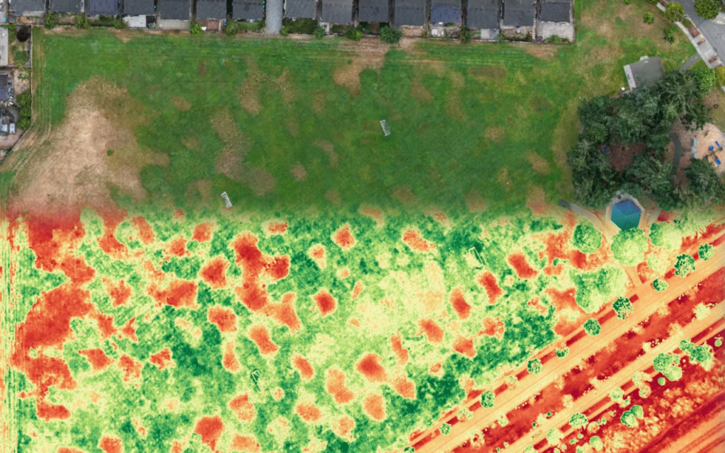
- Plant health (VARI) maps that flag stressed stock before it shows from the ground
- Harvest and block planning from a current overhead view — rows, spacing, gaps
- Season-over-season records of blocks and stock
Resorts & Event Venues
- A guest-facing interactive property map — one link on your website that lets visitors explore the grounds before they arrive
- Event planning from above: layouts, parking, tent and staging placement
- Marketing imagery for your website, listings, and social channels
Golf Courses
- Hole-by-hole imagery for your website, course guides, and member communications
- Drainage analysis from the digital surface model — see where water actually goes
- Current documentation of greens, fairways, and facilities for planning and insurance
HOAs & Planned Communities
- Current records of common areas, amenities, and infrastructure
- Documentation for boards, reserve planning, and insurance renewals
- Before-and-after records for contractor work and storm response
Farms & Ranches
- Field and pasture monitoring without driving every acre
- Seasonal comparison layers — year-over-year change on one map
- Plant health (VARI) maps to catch stress early
Breaking ground on a building project? Construction progress mapping is a separate Focus 56 service with its own page.
Drone Mapping Near Me — South Puget Sound Coverage
Focus 56 is based in Lacey, WA and flies drone mapping services across four counties:
- Thurston County — Lacey, Olympia, Tumwater, Yelm, Rainier, Tenino, Bucoda
- Pierce County — Tacoma, Puyallup, Lakewood, Gig Harbor, Spanaway, University Place
- Lewis County — Chehalis, Centralia, Morton, Winlock, Napavine
- Mason County — Shelton, Allyn, Belfair, Union
No travel fees within the four-county service area. Projects outside it are welcome — travel costs are quoted upfront.
If you’re comparing drone mapping companies near you, here’s what locality buys: Dan lives here, flies here, and schedules around your season — spring bloom, event calendar, harvest window, or the week before your board meeting.
If you searched “drone mapping near me” or “drone mapping service near me” and your property is in South Puget Sound, you found your local provider.
Drone Mapping Cost — Transparent, Project-Based
Every mapping project is different, so pricing is quoted upfront based on:
- Acreage — larger sites require more flight time and processing
- Deliverables — orthomosaic only, or full package with 3D models and interactive web map
- Location — travel fees may apply outside the four-county service area
- Repeat flights — discounted rates for ongoing progress tracking
Typical range: $400-1,500 per project.
You’ll get a fixed quote before any work begins. No hourly billing. No surprise add-ons.
Want your number? Contact us for a free quote — tell us your acreage and the deliverables you need, and you’ll have a fixed price before anything is scheduled.
Frequently Asked Questions
Ready to See Your Property From Above?
Stop making decisions from a satellite photo that’s years out of date. Focus 56’s drone mapping services give you the land you manage as it is today — an interactive web map you can share with anyone, honest planning-grade accuracy, and a fixed quote upfront.
Want to see the deliverable first? Open the McAllister Park or Horizon Pointe interactive maps.
FAA-certified. Fully insured. Local to South Puget Sound.