
Explore Interactive Drone Maps
High resolution orthomosaics. Interactive web maps — pan, zoom, measure, and explore your site.
Focus 56 Drone Map Portfolio
These are orthomosaic maps — high-resolution aerial images built from hundreds of overlapping drone photos, stitched together and geometrically corrected so every pixel represents a real location on the ground.
Each map below is a live, interactive web page. You can pan across the site, zoom in to see individual trees and features, toggle between map layers, and share the link with anyone on your team. No GIS software. No downloads. Just a URL.
Live Map Portfolio
Click any map to open the full interactive version.
McAllister Community Park Location: Lacey, WA Date mapped: August 2026
- 📐 60 acres
- 📷 805 photos
- ✈️ 2 flights (Flights #008 + #009)
- ⏱️ 48 min total flight time
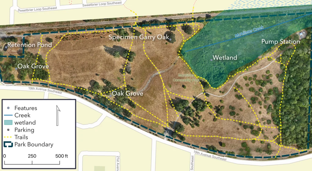
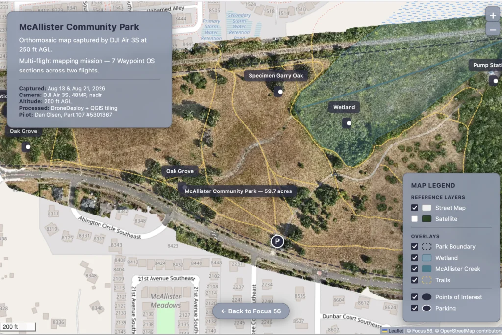
McAllister Park is a 60-acre community park in Lacey — one of the larger green spaces in the area. I mapped it across two flights to capture the full extent at high resolution.
The interactive map includes a high resolution orthophoto layer, OpenStreetMap and Esri satellite reference layers for context — switch between base maps using the layer control in the map legend.
This map shows what’s possible at scale: 800+ photos stitched into a single, seamless, zoomable image of the entire park. You can see individual trees, walking paths, sports fields, and parking areas in detail that satellite imagery can’t match.
Horizon Pointe Park Location: Lacey, WA Date mapped: August 2026
- 📐 10.7 acres
- 📷 144 photos
- ✈️ 1 flight
- ⏱️ 18 min flight time
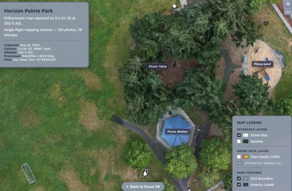
Horizon Pointe is a neighborhood park in Lacey — smaller than McAllister, but packed with amenities. I mapped it in a single 18-minute flight.
This map showcases several features beyond a standard orthophoto:
- Clipped orthophoto — the map boundary is clean, not a ragged rectangle of raw imagery
- VARI plant health layer — toggle on a vegetation analysis that highlights plant health using the Visible Atmospherically Resistant Index. Green areas = healthy vegetation, red areas = stress. Use the opacity slider to compare it against the true-color orthophoto
- Amenity labels — five interactive markers identify key features: Athletic Fields, Picnic Shelter, Picnic Table, Playground, and Basketball Court
- Park boundary outline — the park extent is clearly delineated
The VARI layer is a genuine planning tool. If you manage a park, an HOA, or any property with vegetation, this kind of analysis shows you where turf is struggling, where trees are stressed, and where to focus maintenance resources.
What You Get When I Map Your Site
When you hire Focus 56 for a drone mapping project, you get more than a folder of images. Here’s what’s included in a standard mapping deliverable:
Interactive Web Map Your map hosted on a live web page at focus-56.com. Pan, zoom, measure, and share the link with your team, your clients, or your stakeholders. Works in any browser — desktop or mobile. No software to install, no licenses to buy. This is the same format you see in the live maps above.
High-Resolution Orthomosaic (GeoTIFF) The full-resolution stitched image — every pixel georeferenced to real-world coordinates. Import into QGIS, ArcGIS, AutoCAD, or other GIS software.
Digital Surface Model (DSM) Elevation data for your site — terrain, tree heights, building heights. Useful for drainage planning, line-of-sight analysis, and volume calculations.
Plant Health Analysis (VARI) Visible Atmospherically Resistant Index analysis that highlights vegetation health across your site. Green = healthy, red = stressed. Included on request for any site with significant vegetation.
Custom Map Layers Need reference imagery alongside your orthophoto? Esri satellite basemaps, OpenStreetMap, or your own provided layers can be added to the interactive map. Want amenity labels or boundary outlines? We can deliver custom maps.
Project Files All source data delivered in standard GIS formats. Compatible with QGIS, ArcGIS, AutoCAD, Google Earth, and most GIS/CAD workflows. If you need a specific format, just ask.
About the Pilot
I’m Dan Olsen — FAA Part 107 certified remote pilot (Certificate #5301367), based in Lacey, Washington. I’ve been flying mapping missions with a DJI Air 3S and processing the results with open-source tools like WebODM and QGIS.
I come at this from a different angle than most drone pilots. I spent 30 years as an arborist, so I read the land differently — tree health, canopy coverage, terrain, drainage patterns. I also completed college-level GIS courses, so I know how to process, analyze, and deliver aerial data.
I’m early in this business — building flight hours, building a portfolio, building a reputation. That means every project gets my full attention. You’re not getting handed off to a subcontractor or a junior pilot. I fly it, I process it, I build the map, and I deliver it.
Fully insured. Serving Thurston, Pierce, Lewis, and Mason counties. No travel fees within the four-county service area.
📍 Lacey, WA · ✈️ FAA Part 107 (#5301367) · 🛡️ Fully insured · 🚁 DJI Air 3S
Want an Interactive Map of Your Site?
If you’re planning a project, tracking construction progress, selling land, or managing a property — current aerial data makes better decisions. And an interactive map your team can explore beats a folder of image files every time.
I fly and process every project myself. Fast turnaround — typically 24-48 hours from flight to delivered map. Fixed quotes with no surprise fees.